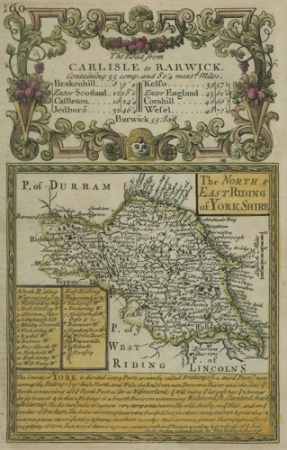
I bought it when I visited Bath in December, so my wife would have something to give me as a present. It's not a very big map — 13cm by 19cm — but the bigger, older, far more impressive map of the area that they had in the shop was six times the price of this one (sigh). My map is from a book, the Britannia Depicta by Owen & Bowen, but in those days map books were made to be taken to pieces and used separately so this is not entirely unexpected. Originally it apparently wasn't coloured, but presumably a map-seller had it done to increase its saleablility.
There are many things I like about this map, but here are a couple of them:
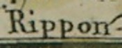
This is how it records the name of Ripon, the (town-sized) city in which I was born. Many people today spell it with two Ps because they don't know it only has one, but 300 years ago they would have been right.
Here's the section with my home town, Hornsea, in it:
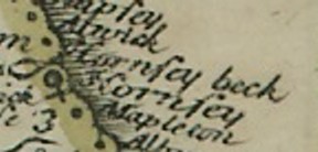
The first thing I like about this is that it has Hornsea Beck on it. By the time this map was published, the village had just about been taken by the sea. The reason it appears is because the map is derived from an earlier map by John Ogilvy, made at a time when Hornsea Beck was still extant.
The second thing I like is the -ey ending on the spelling of the name. It's like that on all the older maps, which suggests either that "sea" was spelled "sey" back then or that it's nothing to do with the sea (or the Mere — the large lake the town is built next to) but has some other origin. I don't know where the town did get its name, but there are lots of Anglo-Saxon place names in the area; assuming Hornsea is also Anglo-Saxon, -ey means "higher land in a marsh"; this fits in with the marshy character of the area before people built drainage ditches to claim the land for agriculture. If the name predates the Anglo-Saxons, however, it's probably going to be Scandinavian in origin, in which case it means "a piece of land jutting out into a lake" with the "sey" meaning a body of water (as in sea, but actually the Mere).
I know, I know, you're not interested...
By the way, yes, I am aware I said this map was the new oldest thing I own.