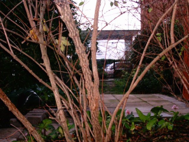
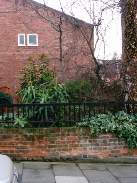
Murderin Bartle RoadAfter his arrest in 1953, John Reginald Halliday Christie confessed to the murder of eight women including his own wife and the wife of one Timothy Evans who had earlier been hanged for the offence. Did you know there is a Bartle link to this serial killer's crimes, though? Here is an email I received from researcher Andy Wynn on the subject: Thought you might be interested in some info I came across on the name Bartle while I was researching a possible book on the Christie murders at 10 Rillington Place, Notting Hill - you may have seen the film. Anyway, Rillington Place was demolished and replaced by BARTLE ROAD, I think named after the Bartle James Iron Works that used to be at the end of it (I found this on a 1914 map of the area). Also the 1901 census lists a Bartle family as living at no 3 Rillington Place then. This email elicited a response from Rob van Estrik: There still remains a connection with the street name Bartle Road and Christie: Christie's wife Ethel had a sister whose married name was Lily Bartle! As you know, Rillington Place was renamed as Ruston Close some time after the murders. Ruston Close is oftenly confused with Ruston Mews, but the latter is an entirely different street that already was there when Rillington Place still existed, located opposite Bartle Road, eastward off St Mark's Road. Unfortunately, Ruston Close was demolished in early 1971, after the street had served as outdoor location during the filming of Ten Rillington Place the year before. After that, the whole area was redeveloped. Today's Bartle Road doesn't really follow the exact running of Rillington Place. The precise location of number 10 is the area between 26 and 29 St Andrew's Square. Some old walling still remains which might originate from the garden walls at the back of number 10. I enclose some photos made in 2003 while I visited the area. You can see the spot where number 10 once stood, plus some of the old stone walling. Rob's message led to an email from John Escolme, shedding further light on the subject: In addition to the items mentioned on your website about Bartle Road, which used to be Rillington Place W11, I understand from a methodist minister that 10 Rillington Place (the location of the Christie murders) was converted into a series of meeting rooms for the Methodist Church when the road was re-named. My source also suggests that the house did not fall down as a result of memorabilia hunters removing bricks from the property, but that this was a myth commonly subscribed to in order to keep such people from visiting the street. It is not clear that the area was re-developed immediately after the filming of the Attenborough movie either (in 1971), in fact it could have been as late as 1979 before the street was demolished. Your Dutch corresspondent suggests that the Christie house would be on the site of the present day 24-26 St Andrew's Square. This could not be so as no. 10 was at the far end of the street (the west end) on the south side with the front facing north - quite the opposite to what your writer suggests. John's information confirmed something Mike Henry suspected: Like John, I believe the street was demolished later than has previously been stated. The following information has come from the Kensington Central Library Local Studies Dept.. I e-mailed them recently to try and get a demolition date (without any luck, but this is what I got back). Rillington Place was built in the 1860s. They had leases for nos 11-20 dating from 1868. The name change to Ruston Close took place in 1954 at the request of the inhabitants. I was also told that the close is listed for the last time in the 1975 London Post Office Directory so I assume that there were people still living there until then. The Royal Borough of Kensington & Chelsea have a website which lists planning decisions dating back to 1948; judging by what these online forms say about the re-development of the area I now believe that the street was demolished around 1976/7. The new development was named as Bartle Road in 1981. A couple of months ago during a frustrating internet search I discovered that the Ruston Close demolition was filmed by a Pathe News crew. A site has the film in stills which you can magnify if you click on an individual frame. It's the entire film, though, so use the next and prev buttons to navigate. I tried to download the film from there without success, however the Pathe back catalogue was bought by ITN so I went to their site and managed to get it this time. With the Pathe site, you may need to register first (it is free, though), then you can access their database. Where it says search, type 10 rillington place then click go. The first item that comes up says DEMOLITION WORKERS KENSINGTON; click on that, then on the next page right click where it says view item and select "Save Target As...". In order to view it, you need Windows Media Player. Warning: at over 3M, it could take a while to download if you have a dial up connection. You will note that the date given by Pathe is 1/1/1971. This could contradict all my earlier information, but I believe it means that all the film on that reel is from that date onwards. This is the one item that casts doubt on my research - it's only John's article that gave me the confidence to come forward. I'm sure that someone will contact your site with the true date someday! Mike has an update to this, having heard more from Kensington Central Library: When I said I assumed that there were people still living there until the 1975 date I was wrong. It turns out that the last year anyone was living there was 1971 and only 3 of the houses had occupants; this means that either Rob's date is correct or that the houses were simply boarded up (the Pathe footage shows corrugated iron over some of the windows) and then left standing as derelict and deserted buildings until the developers moved in. If Rob is correct, then even if it had been demolished the street would have still been on Post Office Records - perhaps because the actual area was still there and hadn't become anything else at that point. The plot thickens! Here's another odd connection to the Christie murders, as related by John Richard Bartle: By pure coincidence in March 1993 my daughter and I both appeared in the first performance of a new one act play "Waiting for Pierrepoint" by the playwright Paul Beard (a friend of mine). Nicola Delaney (nee Bartle) played one of Christie's victims and I played Christmas Humphreys K. C. the defending counsel. The play was entered by The Mitre Players in the national one act Drama Festival, winning the area final and coming within one point of making the National final. This is the brief synopsis that appears in the printed version of the play: "Waiting for Pierrepoint" is an in-depth psychological study into the fragmented mind of the serial killer and self-confessed necrophile, John Christie, as he waits to be hanged. The three key figures in his life, take on the guise of those that have had some effect on his life, in both real and imaginary scenarios. Using archive material and other authoritative sources the text, wherever possible, has been created using the real characters' own words. Small world..! Back on the subject of the murders themselves, I received the following message from Paul Menarry which adds some new data to the mix: Today (06/10/04), myself and a colleague stood on top of the outhouse which consealed Beryl and the child. I can't believe the pics shown on your site are so way off the mark. The popular belief is that an area off Bartle road (where the pictures were taken) has been left undeveloped because that is where the house stood; it's wrong, but convinient. There is no walling left from the house but I can offer a tip to any budding Christie fans: take one survey map (pre-war) and one survey map (present); trace the first and place it on top of the second - the scale needs to be the same, of course. You will then find that the out house can be conviniently walked over as the steps leading to the park are in the exact place. The match is spot on: there's no doubt. I was fascinated to learn that a number of Rushton Mews residents believe that they actually live on the spot! A local librarian states that the electronic gates are there to deter visitors from the site! I also have all the voters lists from 1937. It is interesting to note Beryl was never mentioned in these. I love that "Christie fans" remark! Here's a note from Mike Henry concerning Beryl's absence from the electoral rolls: After seeing Paul's electoral roll list, which was very interesting, I have a possible explanation as to why Beryl Evans wasn't on those forms: she was under age. Back in those days, you had to be 21 to be eligible to vote; I believe she was only 20 when she was murdered. Yes, that would explain it! Paul has the following to say about the 10 Rillington Place movie: Just to finally nail the filming address... The inside shots were filmed at number 8 and the few external shots were filmed outside number 10. If there are any doubters you can count the houses in Rillington Place as Dickie Attenborough walks down the street before opening the door. The number 8 details are hidden in a reference drawer at the local library. Here's a contribution which may interest you, from someone who actually lives in the area, Ilya Haritakis: I have been living on the site of the development encompassing 10, Rillington Place for over 20 years, and have always taken the opportunity to ask older people about the environs of my address. I have been interested in the history of the murderous story, and I think all parties would be interested to learn about a taxi driver's story whose fare I was. One night, a 55-60 year old driver dropped me off round the corner of Rillington Place (Bartle Road) and St Mark's Road. Before taking my fare, he asked me if I knew about the notorious history of site. He asked if he could go down Bartle Road and give me a guided tour. I accepted. It turns out he was a neighbour of the Christies, knew him as a "kindly old man" who would buy him, then a little boy, ice cream when the seller would come near the houses. The houses he said, "were like doll houses", size-wise! They were very narrow, and number 10 is not anywhere near the "empty space" left by the Royal Borough developers between the modern blocks, as a mark of respect to Christie's victims. No. 10 stood only a few yards away from the corner, off St Mark's Road. The course of SMR has not changed as it had to go under the railway bridge. There were houses on Lancaster Road whose gardens backed up on the gardens of those in Rillington Place. All these were demolished in the early '70's and the new development encompassing Lancaster Road, St Mark's Road , the renamed Bartle Road and the newly-created St Andrew's Square (named after the Notting Hill Methodist Church off Wesley Square) was planned for houses built by the Council. This plot was a car park until the RBK&C commisioned William Old to build the present development, completed in late 1977. The date on my lease attests to this. Also the agreement made between the Burghers and Burghesses of RBK&C and the Lessees start the leasehold period of ninety nine years from Feb '78. The first dwelling, 45, St Mark's Road, which was also the show flat for buyers, was aqcuired in April 1978 and has been lived in by the same owners ever since. Therefore John Elscombe is incorrect about demolition in late 1979. I always understood that the name BARTLE was the maiden name of Mrs Evans, whose family lived in a house on the Lancaster Road side; hence, the naming of the road in her memory. I think this is in Ludo Kennedy's book (I haven't got it in front of me). The infamous cafe on Lancaster Road (where Christie chatted up women, luring them to No 10), San Remo Cafe, which became Alistair Little's fashionable Restaurant is now (as of last week[*]) a Malay Takeaway fast food outlet. I just thought I would share an eye-witness account of the taxi driver on the story of Rillington Place. [*] Email received 3rd December, 2004. Barry Corbett has two observations on the story so far, the second of which is particularly authoritative:
In respect of the date of demolition shown on the Pathe website, the pictures would indeed suggest that this event was filmed around 1971 rather than later if you consider the age of the vehicles shown in one particular picture. It would be highly improbable that what appears to be a Commer van, two Morris Minors (saloon and van) and what I believe is a rear end of a late 1960's Hillman Minx would have been in such close proximity without evidence of additional later models of vehicle - should the demolition have taken place at a later period (1975-79) as suggested. With reference to the Post Office London Streets Directory, in this regard I can perhaps give some meaningful information. I have been working for Royal Mail for 25 years, and was involved with Postal Coding & Addressing from 1988 until 1996 where I held the position of Divisional Postcode Manager for London. Whilst the Postcode Address File (PAF) is now updated online with developments and demolition's amended daily, during the 1970's amendments were simply carried out on paper. Documentation was completed by an officer working at the local Royal Mail Area Head Office (in this case it would have been Paddington) before being sent to Chesterfield for manual addition onto a computer. Previous recording of address information was carried out 'locally' using an index card system that was amended with developments or demolition's once the relevant local council had advised us of a change in thoroughfare details. Upon the introduction of an 'online' access system to PAF in Chesterfield that we introduced in 1992, a massive exercise was undertaken by my staff to update all existing index card records in London. It quickly became apparent that many of the records of addresses that we had held for a number of years on PAF were outdated and that incorrect and/or outdated information was being displayed. To this end, the fact that Ruston Close therefore appears within the 1975 Post Office Streets Directory is no surprise. Our paper address directories were primarily used as a means of identifying the nearest Post Office to a London thoroughfare for the delivery of telegrams, and were not updated very often as their sale to third parties was minimal and did not cover the production costs for yearly updated directories. Given these points, the fact that Ruston Close appears in our directory for 1975 is not a true indication that the thoroughfare actually existed at this time. Moreover, records of addressees within old Royal Mail sources such as The Post Office London Streets Directory is also not a definite indication that an address was occupied. As long as an address remains a potential 'delivery point' for mail, it is held on our records pending new occupancy of subsequent change through redevelopment, even to this day. I hope that this information proves useful and I would be only too pleased to hear from other readers of the board that require any further additional information relating to Royal Mail and our addressing history and policy. Nick Allot offers the following help in identifying scenes from the Pathé film:
I have a book New Scotland Yard published in 1954, which devotes a whole chapter to the Christie case and includes a number of photographs. I can't of course be 100% sure, but comparing those photographs with the Pathé news-film from 1971 it looks very much like the house with the white door at the start of the film is/was number 10. In the book, amongst some other photographs of the yard/garden and wash-house at the rear of the house and of the interior of number 10 - which, I might add, the sets used in the feature film portrayed remarkably well - there is one of a passageway leading down the side of the house. I assume this is as shown in the Pathé film, between the house and the wall at the end of the street. I have received the following email from a former resident of Ruston Mews, who wishes to remain anonymous:
I lived in Ruston Mews from [dates removed] and was there when 10, Rillington Place was both filmed and demolished in 1977. Nobody had lived there for 5 years. My neighbour, a builder, used to sell the bricks from RP for £1 each to gullible American tourists, and any doors he found in skips immediately received a one and zero (from Woollies) and these went for £50. Nobody in Ruston Mews believes they are living in Rillington Place. I had the gates put there to stop the hordes of American tourists from gawping at my neighbour's house believing it to be the original maison macabre, as well as to increase security after a severe spate of burglaries. Kensington and Chelsea BC deliberately resited the roads and houses to disguise where RP was. All rubble from the site was removed and crushed to 'sterilise' the site for the benefit of the new occupants and their neighbours, and we welcomed their actions (very much as Fred West's house was in Bristol). At the time the deaths were still fresh in the minds of many of the denizens and to be reminded of them by the ghoulish rubbernecking tourists was (and is) sickening. If you would like to be reminded of the death of a neighbour or friend on a daily basis please let me know and I will put it on Outlook. This correspondence is now closed. |
Copyright © Richard A. Bartle.